How Buffalo valley Got its name
McClain on how Buffalo Valley got its name stated, “Tradition tells us that long
before settlement had been made here that a rank growth of can covered many
square miles and that hers of buffalo would come down from the mountains to
graze through the winter, when other pasturage was dead or scarce. An old
tradition current among early settlers is that a huge buffalo was killed in the valley
near the old Alcorn place, and from this circumstance the valley gained its
name.71
This statement would seem to agree with the early land records as the place
where the buffalo was killed was the Robert Alcorn place (Edward Anderson) 50
acres, west of Capt. Prettyman Jones’s home. It was owned by the Alcorn family
into the 1950’s and until recently was owned by Houston Hayes. Several families
have the tradition that their ancestor killed the last buffalo in the valley on the
Alcorn place. The valley probably go it’s name because the last Buffalo killed in
the area was killed there, but it is also obvious that it was not killed by men who
arrived in the area after 1830 or 1840.
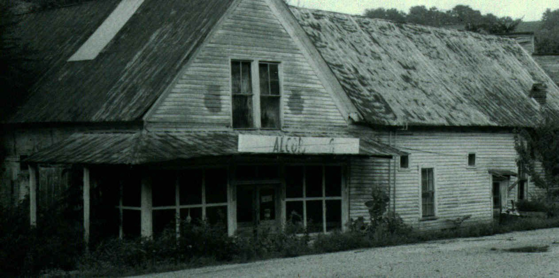
Alcorn place
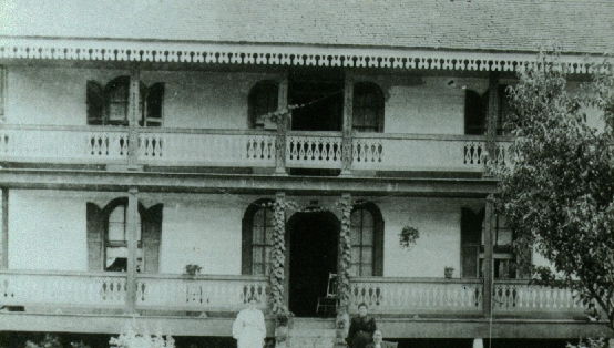
Prettymans house
Buffalo Valley – Putnam County, TN
Written by D. Mitchell Jones
3025 Kline Road
Jacksonville, FL 32216
Buffalo Valley is located in Southwest Putnam County, Tennessee. The Caney
Fork River is the Valley’s western border, and Indian Creek flows through the
Valley and empties in the Caney Fork River. To the Northwest of the Valley is
Rock Spring Creek, and on the South is Wolf Creek. On the North is the
Chestnut Mound area. Prior to the formation of Putnam County in 1854, the
Valley was located in Jackson and Smith Counties as the Jackson-Smith County
line ran in a straight line Southeast from the Cumberland River at the present day
line between Jackson and Smith County line to a point on Little Hurricane Creek. Buffalo Valley got its name from all the buffalo and Elk that ran in the area in the 1800's.
The line crossed through the Valley at about the present day Buffalo Valley
Interchange of Interstate 40. In the early land entries and surveys the area called
“Buffalo Valley” included only the area through which Interstate 40 and the
railroad now run. Entries and surveys for the area show two distinct divisions
such as “20 acres of land in said county in the Buffalow Valley waters of Indian
Creek of Caneyfork”7 or “14 acres in Jackson County on the Southfork of Indian
creek of Caney Fork.8 This distinction continued to be used by surveyors into the
1830’s.
We have been unable to determine the first settler in the Buffalo Valley area, but
some of the first were William Skiles, James Vance and David Young. On 24
October 1803, James Vance of Smith County sold to Armstead Stubblefield of
Sumner County 10 acres of land in Smith County on South fork of Indian Ceek
running into Caney Fork…including said Vances Grist Mill.9 Then on 11
November 1803 Robert King of Roane County, TN sold to David Young of Smith
County 222 acres of land on South fork of Indian Creek that runs into Caney Fork
and lying around James Vances Mill.10 Witnesses to this deed were James
Vance and William Skiles. By 15 March 1805 David Wallis (Wallace) was in the
area, as James Gealey of Smith County sold to David Wallis of Smith County
100 acres of land near the head of the east fork of Indian Creek on Caney Fork
River. Witnesses to this deed was Samuel Norwood and Jacob Fanning.
The land entries and surveys are very informative about the early settlers of the
Buffalo Valley area. Not only do they tell who is entering or having the land
surveyed, but also tells who is living on and has lived on the land. Also the
surveys give the names of two other individuals who were in the area, and they
were the survey chain carriers.
It is interesting that in 1808, we start seeing land activity in Jackson County part
of Buffalo Valley. On 20 April 1808 there were four entries for which James
Vance was the locator. Prittyman (Prettyman) Jones had two of these entries.
The first was for 70 acres and began about 5 poles below and improvement
made by Zachariah Jones where Samuel Brady now lives.12 This land was
surveyed on 19 May 1808 with George Skiles and Edward Reynolds as chain
carriers.13 The second entry was for 50 acres in the Little Bear Valley (of Buffalo
Valley) so to include his improvement where he now lives.14 This land was
surveyed on 17 February 1809 with George Smith of Wolf Creek) and Alex
Reynolds as chain carriers.15 The third entry was by John Clemmons for 60
acres to include the improvement where Henry Karr (Kerr) now lives on which
first was made by James Gealey.16 This land and the next entry was surveyed
also on 19 May 1808 with George Skiles and Edward Reynolds as chain
carriers.17 The fourth entry was by William Skiles for 100 acres whereon said
Skiles now lives.18
The period 1810-1814 saw further activity in acquiring of land. On 2 July 1810
Benjamin Blackburn had an entry for 30 acres in the Buffaloe Valley on Caney
Fork including the place where Robert Wallace lives.19 On 16 December 1811
there were four entries. Jiles Lee entried 20 acres in the Buffalow Valley to
include the improvement whereon the said Lee now lives.20 Three of four entries
were by Prettyman Jones. He had a 30 acre entry in Jackson County in the
Buffaloe Valley standing in the road running up said valley about 275 yards
above James Vance’s 100 acre survey.21 He had another 30 acre in the Valley
about 80 poles westwardly from John Caseys dwelling house.22 He also had a 5
acre entry in the Valley which included an improvement made by William
Hitchcock and a spring.23 One all of his entries Prettyman was the locator. One
of the 30 acre entries was surveyed on 19 September 1812 by James Roulston
with John Dowell and John McKinney as chain carriers.24 The other 30 acre
entry was surveyed on 25 October 1814, and the 5 acre entry was surveyed on
24 October 1814.25 Both were surveyed by A. Harvey with Thomas McGarratt
(?McGarrah) and Robert Wallace as chain carriers.25 On 10 January 1812
Robert Wallace made three entries in the Valley. One was for 40 acres and
included part of improvement of Wm. Skiles.26 He also entered 18 acres to
include the balance of Skiles improvement.26 His other entry was for 10 acres to
include the house and spring whereon Wm. Cotton and Zachariah Kirkland now
lives.26 The survey chain carriers for all three tracts of land were David Wallace
and John Tombolin on 13 March 1812.27 On 8 August 1812 John Casey entered
20 acres of land in Buffalo Valley at the head of Casey’s Spring including the
improvement whereon said Casey now lives.28 James Roulston surveyed this
land on 1 June 1814 with James McKinney and Hezekiah Lizenben (?Hezekiah
Lizenby) as chain carriers.28 On 12 September 1812 Prettyman Jones made a
10 acre entry in the Buffalo Valley at Giles Lea’s (?Jiles Lee) North line to include
the spring and cabin where John McKinney now lives.29 John McKenney on 5
October 1812 entered 10 acres in Buffaloe Valley beginning on East line of
Prettyman Jones 50 acre survey on which he (Prettyman) now lives due East
from said Jones Dwelling House to include all said Jones’s cleared land lying
East of said 50 acre survey.30 This entry was made void on 13 October 1812.30
John Garvin on 13 October 1812 entered 10 acres on the ridge between John
Casey’s and Prettyman Jones’ including a spring on the road leading from
Prettyman Jones’ to John Caseys.31
Major land activity started on Indian Creek in 1807. On 31 August 1807 William
Jared made a 45 acre entry32 and a 100 acre entry.33 Both of these tracts were
surveyed on 11 May 1808, and grant issued on 10 and 11 December 1822. On
23 February 1809 William Jarred (Jared) made two entries of 17 ½ acres each
on the North fork of Indian Creek.34 A. Harvey was the surveyor, and Moses
Webb and Moses Jarret the chain carriers for both tracts on 10 November
1814.34 William Young entered 100 acres on one of the south branches of Indian
Creek.35 This land was surveyed by James Roulston on 30 March 1810 with
chain carriers Tyre Gentry and Samuel Young, but survey was made void on 14
October 1810.35 David Young had an entry for 30 acres on the South Fork of
Indian Creek on 15 October 1810, and this tract was surveyed on 24 July 1813
by James Roulston with Mark and John Young as chain carriers.36 On 22
October 1810 Thomas Green entered 15 acres on waters of Indian Creek
beginning on a corner marked by Daniel Welboun for Hugh Stewart.37 This tract
was surveyed by A. Harvey on 4 November 1814 with Jeremiah Bush and James
Harvel as chain carriers.37
On 10 January 1812 Reuben Harries assignee of Prettyman Jones made entries
for two 15 acre tracts of the dry valley on the waters of Indian Creek.38 On 1 April
1812 James Vance made an interesting entry as it “begin on a hillside between
his sawmill and the top of the hill in nearly a southwest course from said mill and
on the upper line of a 640 acre tract of land that he the said Vance sold to John
Lancaster running North and East in square so as to include said Vances house
and mill.”39 This entry was made void on 16 July 1813, and probably because
the land was entered on that date under a different entry. As on 16 July 1813 he
entered 72 ½ acres and 10 acres. The 72 ½ probably included his sawmill and
house as it begin on North side of Indian Creek at the North East corner of the
640 acre survey of the said Vance.40 The 10 acre entry was also on North side
of Indian Creek and included a spring and an old still house.40 Both tracts were
surveyed on 5 April 1814, chain carriers were Jacob Cloer and Austin Coker.40
On 2 June 1812 David Young made two entries on the South fork of Indian
Creek. One was for 14 acres beginning 5 poles North of the mouth of a cave
near the head of said Youngs mill pond, and had one corner on the East line of
his 30 acre survey.41 It seems obvious that if David Young had a mill pond then
he had to have some type of mill. The other entry made by David Young was for
31 acres near Jesse and John Wammacks spring branches including the place
whereon Jesse Wammack now lives.42 The chain carrier on this tract were Mark
and John Young and on prior tract the chain carriers were James and Mark
Young. Both tracts were surveyed on 24 July 1813 by James Roulston.
Also on 2 June 1812 John Jones entered 15 acres of land.43 Jonathan Reno was
the locator on 11 August 1812 when James Vance entered ½ acre on a drain the
South Fork of Indian Creek, and included a salt petre cave about ¾ of a mile
above David Youngs big spring.44 Duke Skelton entered two tracts of two acres
each on 17 August 1812.45 One tract was on Indian Creek and included John
Christians house and spring.45 The other tract was on the road from Waltons
Ferry to Southwest Point, and the tract included part of a field he occupied.45 On
14 October 1812 Jonathan Reneau (Reno) entered 5 acres in the dry valley of
Indian Creek above Reuben Harris’s.45 This land was never surveyed. James
Vance had another 10 acres surveyed on 4 October 1814 with George Collom
and John Wilds as chain carriers.47 This tract of 10 acres began on Vance’s
South East corner of his 10 acres survey and ran South 34 poles on the North
line on his 640 acre survey.47
We are including information from the land records for Rock Springs area as we
see some of the individuals mentioned previously with other individuals which
may indicate family relationships. Samuel Roulston entered 1,000 acres on 25
February 1801 and was surveyed on 22 September 1814. The entry begins on
the point of a ridge above the spring wherein Shadrick Bridges now lives. It
crossed Rock Spring Creek and also included the Southside of the dividing ridge
between Rock Spring and Indian Creek and the spring known by the name of
rock spring.48 On 18 February 1808 Richard Reynolds had 137 ½ acres on Rock
Springs Fork surveyed with John and Firney Reynolds as chain carriers.49
James Roulston had a 50 acre entry on Rock Springs in Jackson County on 22
February 1809 which began on North side of the Lancaster Road on a point of a
ridge where David Parker now lives.50
There were several entries made by individuals in the Rock Springs area on 10
January 1812, who apparently purchased part of a land warrant from Prettyman
Jones as they entered land as assignees of Prettyman Jones. Two of these
entries were made by David Wallace for 30 acres each. One tract was on the
Southside of Rock Spring Creek including the improvement made by Richard
Reynolds.51 This 30 acres was surveyed on 13 march 1812 with Thomas
McGarrah and Robert Wallace.52 The other 30 acre entry by David included the
improvement and spring whereon the said Wallace now lives.53 Henry Carr had
one entry for 30 acres which included a cabin built by Thomas Smith.53 Thomas
McGarah had a entry for 20 acres to include the improvement where he now
lives.53 On all of these entries Prettyman Jones was the locator. George Collum
also as assignee of Prettyman Jones entered 70 acres of land in Smith County
on Rock Spring Creek to include said Collum’s improvement.53 On 22 February
1812 John Boyd made two entries for 15 acres each at the head of Rock Spring
Valley and one of the entries begin south of McCager Browns Spring.54 Then on
1 April 1812 Shadrach Bridges entered 22 acres on a branch of Rock Spring in
Jackson and begin SouthWest corner of his tract of 50 acres where he now
lives.55
George Skiles entered 25 acres in Jackson County on Rock Spring creek on 2
June 1812.56 Joseph Jared under entry number 8754 made a 5 acre entry on 24
August 1812 in Jackson County in Rock Spring Valley to begin on East line of his
survey of 20 acres and including a small field cleared by Reuben Smith.57 Also,
on 24 August 1812, Henry Carr made three entries on Rock Spring Creek. Entry
$8755 for 15 acres included the “cabbin” built by Thomas Smith about ¼ mile
below Jacob Fainnings.57 Henry’s Entry $8756 was for 10 acres joining the East
line of David Wallace upper 30 acre survey up the creek so as to include the old
school house place where Allen Harvey formerly kept school it being his upper
school house.58 Henry’s third entry was #8757 for 5 acres beginning at David
Wallaces Southeast corner of his upper 30 acre tract.58 Another interesting entry
was made by Joseph Jared for 20 acres in Smith County on Eastside of the
Caney Fork River, and it is reasonable to believe this was in Rock Spring area. It
began on the River bank about 60 poles above Spryas Kirklands improvement.59
The tract was surveyed on 11 May 1816 with Henry Carr and Moses Justice as
chain carriers.59 A note on the survey says it was transferred to James Carr, and
taken out on 25 August 1818 by Shadrack Bridges.59
Three other entries of interest were just outside our area of discussion. The first
entry was for 7 acres on 14 October 1812 by Hezekiah Lizenby in Jackson
County on the ridge between Buffaloe Valley and Hurricane Creek.60 The other
two entries were made by Nathaniel Glover on 26 January 1813. One entry was
for 15 acres in Jackson County on water of Hurricane Creek including the
improvement whereon James Karr now lives.61 This tract was surveyed on 31
May 1814 by James Rouston, and the chain carriers were John Gawan (Garvin?)
and Hazekian Lazenby.61 Glover’s other entry was for 10 acres in Jackson
County on the ridge that divides the waters of Woolfe and Indian Creek including
the place whereon Mrs. Pattey now lives. James Roulston surveyed this tract on
1 June 1814 with Hazakiah Lazenby and John Garven as chain carriers.62
BUFFALO VALLEY – PUTNAM COUNTY, TN
By D. Mitchell Jones
Volume XVII, No. 2 - UCGA
Studying the migrations into and out of an area can give the researcher important
clues to family relationships. Normally families moved together or followed other
family members or friends to a new area. From the families that we will discuss
later; we can see that the prior statement is true for individuals in the Buffalo
Valley area.
James Vance63, born 3 September 1764 Bucks County, Pennsylvania, and died 7 October 1835 in McDonough County, Illinois, and was the son of Samuel Vance and Agnes Penguite. He married 28 January 1782 Margaret Reno (Reneau) daughter of John Reno (Reneau). He owned a grist mill and sawmill in Buffalo Valley. He may have been a member of the County Court as 1811.
.
.
Voters List of Jackson County lists him as James Vance, Esquire. In 1818 he
was one of the commissioners appointed to lay out the new town of Gainesboro,
Tennessee. His son, John, said he was born in 1794 in Cocke County area as
Cocke was formed in 1797. In 1796 James moved to Davidson County,
Tennessee where he had a brother, Thomas Vance. In 1800 or 1801 he moved
to Buffalo Valley area. Children: 1. Mary (Polly), b. 31 December 1782; 2.
Elizabeth, b. 17 October 1784, d. 26 January 1847, md David Young; 3. Nancy,
b. 5 October 1786, d. 30 Oct/Dec 1851, Illinois; 4. Sarah, b. 9 October 1788, d.
12 May 1791; 5. Sarah, b. 17 August 1791, d. 1 December 1875, Illinois; 6. Lewis
Reno, b. 29 January 1793, d. 28 June 1852 en route to Salt lake City, Utah, md
12 February 1815, Elizabeth Roulston. 7. John Alma, b. 8 march 1794, TN, md
11 February 1817 Sarah Lavina Perkins daughter of Ute Perkins and Sarah
Grant, Ute and Sarah lived in White Co., TN, John lived in Jackson Co., until
about 1824 when he moved to Morgan Co., Ind. Then about 1829 he moved to
McDonough Co., IL where his wife died in 1836; 8. Agnes P., b. 25 June 1796
Smith Cp., TN, d. 19 August 1836, md John Rogers; 9. William, b. 25 June 1796
d. 25 November 1800; 10. Margaret, b. 14 1800, d. 23 January 1892, md John
Bridges; 11. William Reno, b. 18 July 1802, Jackson Co., TN, d. 11 November
1880, md 15 October 1828 Elizabeth Boyd; 12. Martha Ramsey, b. 16 May 1804
Jackson Co., TN d. 26 April/May 1881, md 30 October 1828, McDonough Co.,
Illinois, John Wilson; 13. James R. b. 30 July 1807, Jackson Co., TN, d. 27
September 1872, md 25 August 1830 Ellen Miller.
Matthew Roulston had six children who may have had some association with
Buffalo Valley. Children:64 1. Moses, b. 1766, md 20 October 1803, Polly
Denny. He was a teacher, and lived most of his life in Chestnut Mound area.
Moved to Blount Co., TN and then to Hamilton Co., TN; 2. William, b. 1768, md 6
September 1799 Ann Moore. He moved to Williamson Co., TN; 3. Elizabeth, b.
1770, md 6 December 1792 (Book of Jared says in Bedford Co., VA), William
Jared, b. 3 June 1758. He moved from Loudon Co., VA in 1785 with his father to
Bedford Co., VA. He was in the Revolutionary War; 4. Samuel, b. 1775, md
Betsy Lowry. He moved to Sumner Co., TN. 5. James, b. 16 June 1778 August
Co., VA, md 1801 Knoxville, TN, Jane Simmons, daughter of Robert Simmons.
He moved with his father in 1792 to Jefferson Co., TN. He moved after his
marriage to the Chestnut Mound area, and operated, with his brother-in-law,
Mark Young, an inn, powder mill, a distillery and a large farm. He was also a
land surveyor. In the War of 1812, he was a colonel in command of the Third
regiment of Tennessee which was part of General William Carroll’s Division in
the Battle of New Orleans. He moved from the area to Marion Co., TN. 6. Ruth,
b. 1781, md Mark Young. They lived in Buffalo Valley, TN.
Starting in 1803 several families moved from Blount County in East Tennessee to
the Buffalo Valley area. Those known to be from Blount included: John
Clemons, James Gealey, William Hitchcock, Prettyman and Zachariah Jones,
Moses Justice, George and William Skile, and David Wallace. Others who may
have come from Blount County may have been James Carr, James McKinley,
John Null, and James and Robert Wallace.
There is only one reference to Moses Justice in the records of Buffalo Valley, but
his family had other connections with the Valley. Moses Justice born ca. 1755 in
Maryland. In Cheran District South Carolina in 1790. Removed from Indian
lands Blount County Tennessee in 1797 along with James Gealey, Prettyman
and Zachariah Jones. In Crawford County, Indians in 1820 and then moved to
McDonough county, Illinois. He then moved to Schuyler County, Illinois where
he died ca. 1847. His children:65 1. James; 2. Sarah, md 23 April 1798, Blount
Co., TN, David Campbell Wallace, b. between 1770/80, probably brother of
James and Robert Wallace. He had a license to operate a tavern in Smith
County in 1818. While in Smith County he served on various juries, and was the
Smith County Representative to the Tennessee General Assembly, 1819-1821.
He moved to Schuyler County, Illinois. 3. Mary, b. ca. 1783 in TN, md by
Matthew Wallace on 7 January 1802 in Blount Co., TN, George Skiles; 4.
Thomas Jefferson, md Mary Carr. In 1820 they were in Greene Co., MO, and in
Schuyler Co., Illinois 1830-50. After 1850 they were in St. Clair Co., MO. 5.
George Washington, md Susan bates; 6. Rebecca, md Samuel Monk; 7. Hannah
md Drurey Trusty; 8. John, b. 1797, lived Schuyler Co., IL.
One of the unique migration patterns was that of George Skiles. George Skiles
was born c. 1780 in Maryland, died 4 August 1863 in Schuyler Co., Illinois and
married 7 January 1802 in Blount County, Tennessee Mary Justice, b. ca. 1783
in Tennessee and died 1874 in Schuyler County, Illinois. By 1808 he was in
Buffalo Valley where his brother was present as early as 1803. He was an
ensign in Mathew Cowan’s Company of Colonel Rouston’s Regiment during the
Battle of New Orleans in 1815. In 1816 he moved to Indiana, then to Kentucky,
then to Wayne County, Missouri and by 1826 was in Schuyler County, Illinois.66
In the 1830 census of Schuyler County Illinois, he is found with his brother,
William Skiles, John and William Carr, Nathaniel Glover, Abraham and Hugh
Lancaster, Abel and John Linsenby, Charles and Jacob Reno, Jonathan Smith,
Peter Vance and David Wallace. Of George and Mary’s thirteen children we
have identified the following: 1. Moses J., b. 1803, TN, md 1st Mrs. Swazey, md
2nd Mary Luttrell, daughter of Shelton Luttrell and Sarah (Sallie) Bryant, md 3rd
Malinda Lynch; 2. Mary, b. ca. 1815, Jackson Co., TN md Hiram Scott; 3. James,
lived Alma, Nebraska; 4. John, trained as a minister of the Methodist Episcopal
Church; 5. William C., b. ca. 1820, Wayne Co., MO, d. 12 April 1907 Schuyler
Co., IL. Convert to Union Baptist faith and was a circuit rider minister with his
brother, John in Illinois, Iowa and Nebraska, md Sarah Luttrell, daughter of
Shelton Luttrell, b. 12 May 1794 in VA, d. 6 April 1883, Schuyler Co., IL and
Sarah (Sallie) Bryant, b. 25 June 1792 in Patrick Co., VA, d. 29 may 1894 in
Schuyler Co., IL. Two of the people who witnessed the pension application of
Mary Skiles were Joseph Reno and Alfred C. and Samuel F. Wallace.66
Another Buffalo Valley area family in Schuyler Co., IL was Felix Thorton and his
wife Mary Celetha Holly. They moved to Schuyler County in 1829. One of their
sons was Felix H. Thornton, b. 10 September 1819 in Jackson Co., TN, md 23
June 1844 in Schuyler Co., IL, md Ollie Luttrell, b. 8 June 1826, daughter of
Shelton Luttrell and Sarah (Sallie) Bryant.68
Jonathan Reno with his wife and children were in Schuyler Co., IL by 1825.
Later he moved to McDonough Co., IL by 1825. Later he moved to McDonough
Co., IL and then to Springfield, MO. After his death his wife returned to Schuyler
Co. In 1811 Jonathan was a Captain, 18th Regiment, Jackson Co., TN Militia.69
His children we have identified are: 1. Joseph, b. 1808, TN, md Sarah ___b. ca.
1915, TN; 2. Jonathan, b. 1811, Jackson Co., TN, d. 1884, Schuyler County, md
abot 1834 Louisa Thornton, b. 1822. They had a son, William C. Reno, b. 9
September 1838 Schuyler County, me 18 October 1861 Schuyler County.
Rebecca A. Wallace thought to be a daughter of Alfred C. Wallace. 3. Andrew J.
Reno, b. 1816? Jackson Co., TN, md Mary P_____b. 1817, MO.
We have mainly mentioned families that moved from Blount County to Buffalo
Valley and then on to Schuyler Co., IL. These families show that people moved
together and that they married within those families for several generations.
In most of the published literature that mentions Buffalo Valley it is referred to as
nothing really existed prior to 1860. We have seen from the early land entries
and surveys that there was much activity in the area at an early date. James
Vance had a grist mill prior to 24 October 1803, and a sawmill by 1 April 1812.
By 2 June 1812, David young had some type of mill. From the old store ledgers
we know there must have been a church in the area by 1832, as there was a
“Parson” Lee. The earliest store ledger is Ledger D with first date in 1832, and
there must have been an A,B, and C. Since Ledger D covered about ten years; it
would seem reasonable that the store was probably started no later than 1826. It
is my best guess that the store was on Indian Creek and owned by Vance &
Young. In two of the ledgers a firm of Vance and Young is mentioned, and the
account for Vance & Young shows only cash entries. Initially it was though the
store was in Chestnut Mount area, but it had to be more centrally located as the
town of Lancaster was formed in 1818. Lancaster would have been much easier
to reach than Chestnut Mound. In the Rock Springs area, Allen Harvey had two
schools prior to 24 August 1812.
Anyone interested in the early settlers of Buffalo Valley should also consult the
1812 voters list by James Vance on page 7, Volume V, No. 2 of the UCGA
Bulletin. We also await with interest the every name index to land Entries of First
Surveyor’s District by Norman McGee. This nearly completed work which will
cover several Middle Tennessee counties from 1807 to 1823. This monumental
work will be indispensable for family research in early Tennessee. There follows
some plats from the early land records. Platting the early land records is very
difficult as many land entries were never granted. Also some later surveys and
grants encircled earlier entries and surveys. At this time we have not been able
to place David Young’s land in relationship to the land of other individuals.
We also await with interest the every name index to land Entries of First
Surveyor’s District by Norman McGee. This nearly completed work which will
cover several Middle Tennessee counties from 1807 to 1823. This monumental
work will be indispensable for family research in early Tennessee. There follows
some plats from the early land records.
I would welcome correspondence on this article. D. Mitchell Jones, 3025 Kline
Road, Jacksonville, FL 3221
Article wrote UCGA, 1992
